
The City of Healdsburg is located in Sonoma County, approximately 70 miles north of San Francisco, situated along the Russian River, at the confluence of three valleys: Dry Creek, Alexander, and Russian River. The region is characterized by a moderate climate, rich alluvial soils, and abundant natural resources. Healdsburg’s history is intimately tied to its natural abundance, afforded by the fertile alluvial deposits of the Russian River and a moderate climate. A mix of Oak grasslands, forest, and riparian habitats have long afforded the region abundant agriculture, viticulture, recreation, and even gravel mining.
The City operates over 350 acres of open space preserves and public parks. Fletcher Studio was selected by the City of Healdsburg to develop a comprehensive open space and connectivity master plan for the City’s parks, open spaces, and natural resources with a particular emphasis on green modes of transportation and safety.
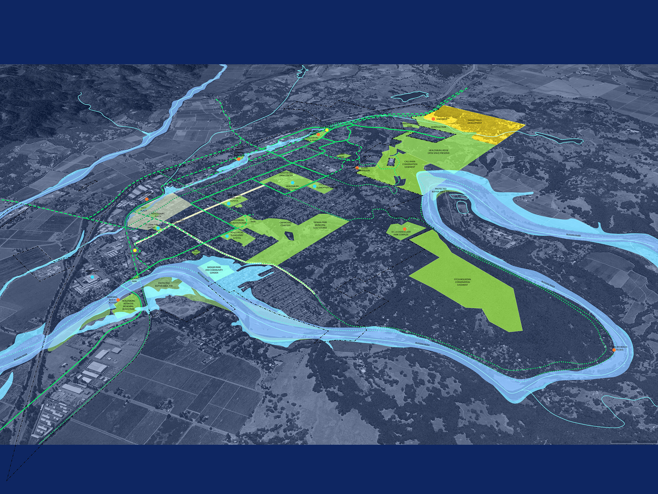
Further, an inter-agency team comprised of City and County agencies, along with hydrologists, ecologists, and key stakeholders, are developing an access plan for the Russian River in Healdsburg with focuses on restoring native habitat, reducing flooding risk, and enhancing people’s understanding of and engagement with the River.
Connectivity, Community, and Resilience
Project Information
Date: 2019 - Present
Size: 350 acres
Client: City of Healdsburg
Role: Landscape Architecture & Planning
Features: Ecological Preservation, Flood Mitigation, River Access & Connectivity
1. START-UP
Working with city staff, the design team attended initial meetings with key stakeholders to walk and bike the site as a group, discussing opportunities. Following the site visit, the team lead an informal charrette with attendees to start identifying important areas of the open space while exploring initial design and programming ideas. Following these engagements, the design team prepared project mapping and site analysis.


2. SITE ANALYSIS
The design team gathered site data into a 3D model, reflecting the existing vegetation, topography, remnant golf course features and creeks. The team interfaced with hydrologists to opine on recommended buffers from creek banks and hydrological implications of potential design interventions. Conversations with city staff during this phase were centered around the details of developer agreements and neighborhood concerns. The team interfaced with the City about how to approach specific topics with the surrounding community. Site constraints and opportunities were mapped and coordinated in collaboration with the City.
Healdsburg Connectivity - Current/Planned Routes and Destination Map
3. PARK DESIGN TEAM
Fletcher Studio worked with the client to form a Park Design Team (PDT), which consisted of a 45 person committee of volunteers from the community. The PDT worked directly with the design team over the duration of the design process. Serving as ambassadors of the design to neighbors and the community, the PDT worked collaboratively with the Consultant to review and provide comment and insight on plan iterations, particularly at major developments in the master plan. Evening Zoom meetings were conducted every 3-4 weeks to review progression of the masterplan and confirm buy-in from the committee.


4. STAFF MEETINGS

The Consultant met with facilities, recreation and maintenance parties who were interested in the future of the project. This included representatives from the maintenance division of Parks and Recreation and Public Works and Utilities staff as well as the Community Services division. Understanding City workflows, maintenance regimes, and constraints were critical to realizing a master plan that is responsive to the community and city’s aspirations and goals.
5. FINAL PLANS

At this point in the project, the team onboarded civil and electrical engineers to verify that the proposed utility connections were feasible, verifying proof of concept. CEQA and other hydrological consultants reviewed the plans and helped navigate future pathways for permitting and agency outreach. Concept master plans were vetted for any ‘fatal flaws’ pertaining to stormwater treatment strategy, utility assumptions, proposals within easements, etc. Supporting ROM cost estimates were provided at this time by a cost estimating sub-consultant to the landscape architect.
6. open house
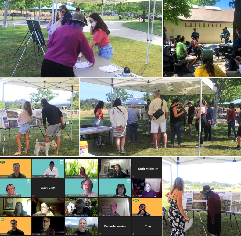
The design team met with the public on-site at the project with posters and information on the proposed design. Site walks or bike-abouts were conducted by design team and city staff to tour proposed improvements with interested attendees. The Park Design Team attended an Open House, and served as ambassadors for the design process. The open house was a unique on-site opportunity to share the masterplan with the broader community, build momentum, gather input, and celebrate the potential of the open space as a community. Such events not only provided key engagement opportunities, but also cemented the community’s support for the masterplan prior to official commission and council hearings.
7. COMMISSION

The design team developed a presentation for the City Staff report that was first presented to the Parks and Recreation Commission in-advance of presentation. The team recommended a two-step meeting format, with (1) preliminary presentation to the commission to introduce them to the project, and (1) final presentation to ask for approval. Commission members were invited to attend the Park Design Team sessions, which turned out to be advantageous to the approval process.
8. CITY COUNCIL

Finally, the design team led the development of the presentation slides for the City Council Approval. This was done in a similar two-step meeting format as Commission meetings were conducted in the previous step, with (1) preliminary meeting, and (1) final presentation for approval.