Reimagining a Riverside Park
Badger Park
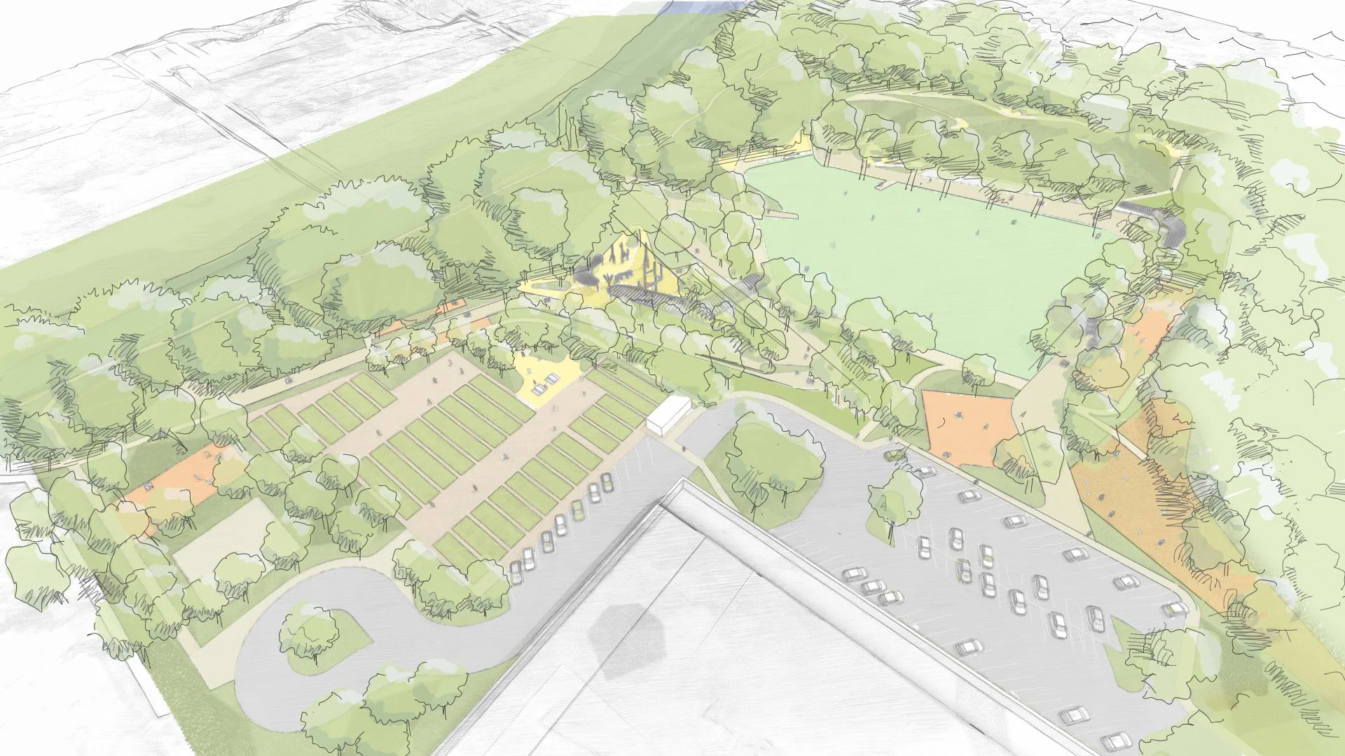
Badger Park is located on the south side of the City, along the Russian River, and is the City’s largest park in its present inventory. The park’s current programming includes: community gardens, children’s play area, a dog park, and a large walking circuit. However, the site’s needs and usage have formalized and increased. Further, the park is expected to be a key recreation area for the Mill District, a 9.6-acre community being developed in Downtown Healdsburg.
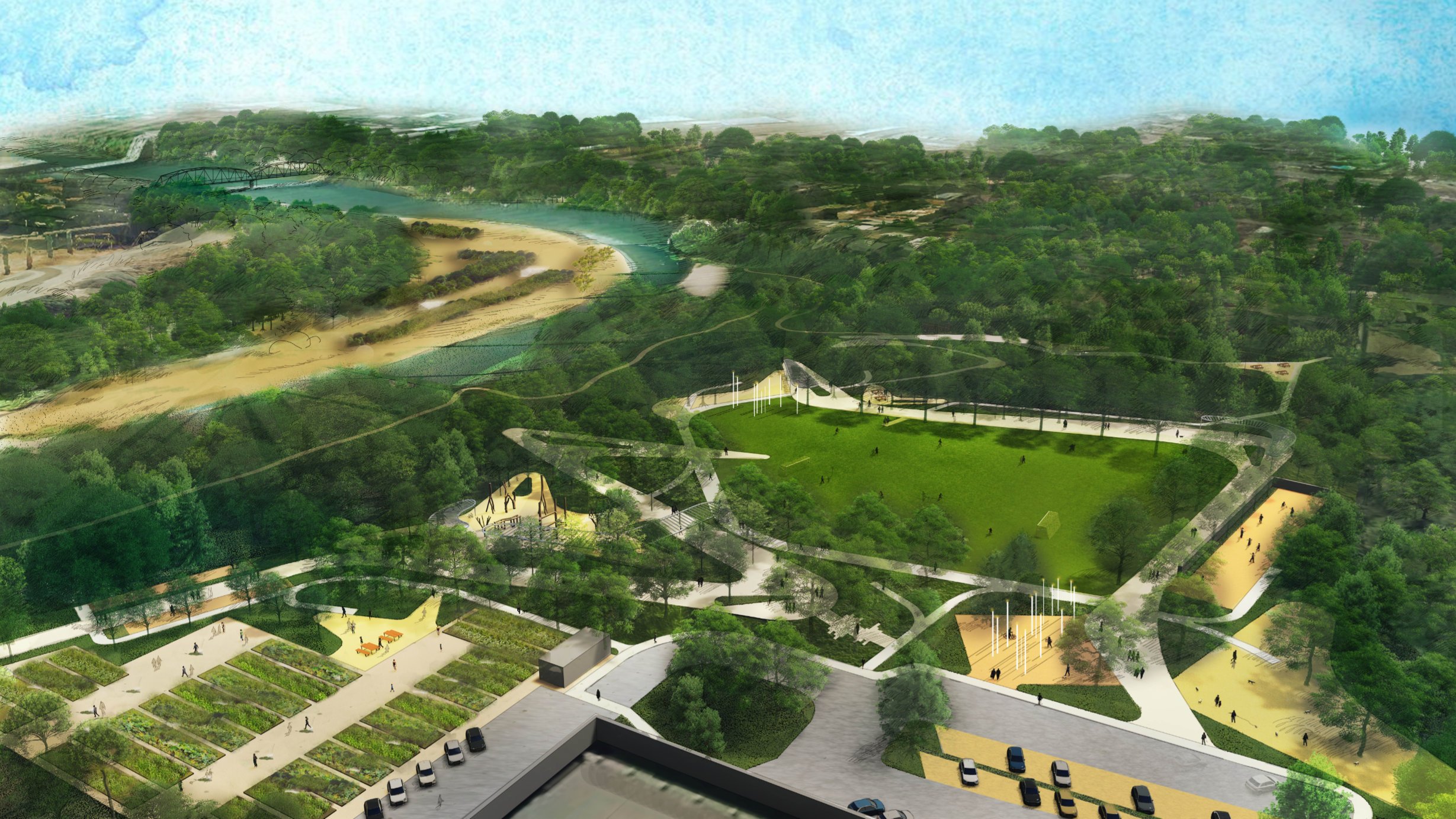
The Park is currently loosely divided into two areas; large, open areas and dense forest along an unnamed creek and the Russian River with informal paths weaving throughout. The forest is heavily impacted by invasive species, principally Arundo and English Ivey. In 2019, Badger Park experienced significant flooding, with approximately 85% of the park experiencing inundation. Fletcher Studio is working with the City of Healdsburg, Parks Design Team, Inter-Fluve hydrological engineers and the Russian Riverkeeper to develop strategies for a resilient, floodable park, that safely connects people to the river, enhances eco-literacy, and supports both social and natural ecologies.
Project Information
Location: Downtown Healdsburg, CA
Date: 2019 - Present
Size: 11 acres
Client: City of Healdsburg
Role: Landscape Architecture & Planning
Features: Ecological Preservation, Flood Mitigation, Public Parks, River Access & Connectivity

Site Photos


Major Design Moves
VEGETATION MANAGEMENT STRATEGY (REMOVAL OF INVASIVES, UNDERSTORY CLEARING)

The following Badger Park design corresponds to the design moves highlighted below:
The proposed design restores the riparian habitat and creek area bisecting the park.
The riparian area on the west and south side of the central lawn require management for fire safety and removal of invasive species for overall habitat health improvements. The design includes selective edits to the understory to this end, while opening views through the vegetation to the river’s edge. The top of bank area (shown as a white dashed line in image at right) has natural promontories looking down river, which become important areas for overlooks and seating in the proposed improvements.
The scheme grants greater access to the river via trails, overlooks and a possible kayak put-in. Low flow during summer and stagnant warm waters could be improved with dam removal at Memorial Beach, which would allow kayak’s entering the river at Badger to continue further downstream. Direct trail access to the gravel Syar bars upstream is maintained and enhanced (see River Access).
The perimeter parking is edited along the edge of the park to limit extrusion into the central park area — creating more room for park improvements and programs. The existing dog play area is moved away from the existing substation to a better location that relates to other park improvements.
The existing community garden stays in the same location as it is in the existing design, and is expanded to the south towards the river to accommodate additional parking. Where possible existing soil will be retained or reused, and transplanting will occur as needed.
The scheme includes a new river-side feature named ‘Willow Island’ which will serve as a shaded willow beach area for passive recreation.